Sunday, March 27, 2011

PLAYAS TO PAMPAS

Puerto Montt is set on hills above a sheltered harbour. We drive along the waterfront and explore a few small fishing towns before hunting down a place to balance GR2's wheels. This exercise means we get a good look at the suburbs. This completed we now plan to head to the coast via Lago Llanquihue and Volcan Osorno. When we arrive it is such a glorious day we drive right up the side of the volcano (nearly to the snowline) 
John isn't feeling too fantastic, so we hole up for a few days beside a river and then the lake. Then it is on to the coast to the playas (beaches) via the city of Valdivia. The city is set on a large river and a huge wetland area - very pretty. We meet some of the locals (a group of sealions) down by the river, and see them again at the fish markets waiting to be fed. A very environmental way to clean up.
On to the beach to explore, first the old Spanish forts in the area and then to follow the lovely coastline north. Once we have had our fill of dirt roads we head east towards the border via Villarrica & Pucon. We were in Pucon in January, and the place was packed. Now it is very quiet and the camp site we intended to stay in is closed, so we park  for the night right in town on the waterfront.
The next day was another border crossing - we made sure we got our full 8 month vehicle permit. We had exited Chile with great views of Volcan Villarrica, and entered Argentina with views of Volcan Lanin. Each side of the Andes is so different. Chile with lush forests and Argentina with dry open spaces.
After Lanin Nat Pk we head south to drive the Route of Seven Lakes that we missed previously due to rain. It was very pretty, but we have probably seen enough lakes for a while, so it is time for new horizons and we head north into the pampas. Not lush farmland, but dry scruffy desert with huge blue skies, with the occasional gorge or two thrown in.
We stop at the town of Zapala to get a leaf taken out of the springs - in readiness for more dirt roads ahead........more to come
Adios Amigos

PLAYAS TO PAMPAS

Puerto Montt's harbour - well the pretty part
Old style wooden house - covered in wooden shingles and on stumps
Local street
The local boys in Valdivia
Getting a bit stroppy - he had to be chased out with a rake!
Local fishing boat
West coast beaches
Keep those cattle working
Fishing village on coast

Pucon - with Volcan Villarrica
Great camp spot in Lanin Nat Pk
Local colour in the Pampas
I know - getting arty!!! Route of 7 Lakes
Pampas - Steppes
Volcano Osorno - for some reason this photo refused to stay in order!!! It should be near the top in Chile

Thursday, March 17, 2011

CARRETERA AUSTRAL PHOTOS


Heading to the Carretera from Argentina

The Carretera beside the Rio Baker

Church in Cochrane


Tortel

Tortel

More of Tortel

Water!!!!

Waterfall at conflugence

My most favorite campspot

Marble Chapel

Marble Chapel


Cemetary

Water everywhere

A great campspot

Johns favorite thing

Yay!!! Tarseal


Wow

The new and the old


They have Wicked vans here

Our mossy forest walk/run

Colgante Glacier


Police caravan


THE CARRETERA AUSTRAL (OR RTA7)

We have returned to Chile to drive this famous route. We cannot start at the sourthern most part at Villa O'Higgins as the border crossing is only for walkers and cyclists (as a boat trip is required), so we have crossed into Chile further north and then have headed south to Cochrane where we are relieved to find a supermarket to restock our food. The same shop can also supply us with shotguns, saddles and outboard motoras.
As we head south the weather  deteriorates to drizzle & then to rain. We are surrounded by mountains, waterfalls and forests. There is water everywhere. All the surfaces drip with water. It runs down mountainsides and sloshes down the sides of the road. In fact a lot of the road consists of causeways through thr water. The road gets narrower and even more potholed.
We finally reach the very quaint town of Tortel, right at the mouth of Canal Baker, that leads to the Pacific Ocean. Donning fill wet weather gear and umbellas we head out to explore (no driveby here as cars are excluded) the maze of wooden walkways down the cliff and around the village. After some great wild salmon & chips we head to the landing strip (the only flat area near town) to camp in the hope that the rain clears. No joy here, it rains all night. We even develop an unfortunate leak in the night right over my side of the bed.
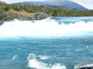
We do not plan to go any further south as it involves ferry crossings and even worse road. So we return north, hoping for sunshine, or at least no rain. It does finally improve before we reach Cochrane and we do have a few gorgeous days. On one of these magical days we walk to the conflugence of the Rio Baker & the Rio Nef. The sheer volume of gorgeous jade water from the Baker meeting the milky white water from the Nef is amazing. Another side trip is out on Lago General Carrera to see the Capilla de Marmol (marble chapel) - an amazing geological formation.
After miles of dirt road we meet pavement at the little town of Cerro Castilla and this continues all the way to the biggest joint down here - Coyhaique, where we shop, fuel, water & find free Wifi (giving us a chance to see Sammy again)
As we leave town our spell of fine weather leaves us. After all summer is over (they only have 2 months here) and tourists are vanishing fast. Only a few hardy cyclists remain. This is one of their epic journeys. We continue through rugged gorges with ranges covered in mist, and follow rivers to Puerto Aisen (this route being the one that is sealed) - a rather scruffy town that is notable for producing fish meal for salmon farming. It is a bit dull, wet & depressing, so we continued on along lovely smooth roads through volcanic valleys and then more river gorges to little Puerto Cisnes. John had been hanging out for another salmon meal here at El Guainao recommended by Lonely Planet & a friend. Sadly it was closed, so he had to have take away salmon (actually delivered to GR2's side door) instead.
Then back to Rta 7, and what a shock. It is back to the original narrow, potholed, corrugated dirt road, but with gorgeous lush rainforest and amazing glaciers in the mountains above us. It was a pretty awesome drive for me and a busy one for John as he "manages" the drive. After a lot of hairpins we reach the sound and the Parcque Nacional Queulat to see the Colgante Glacier. We decide to do the 2.5 hr trek as soon as we arrive because the sun is shining and who knows what tomorrow holds. So there we are (well John with a sore leg and me just plodding fast) at 6pm at night doing our trek. The glacier was fantastic - we had 10mins to stare at it , before rushing back down through thick, mossy (and by now rather dark) forest. What a crazy thing to do!. Thank goodness the next morning was cloudy and the day turned to drizzle and rain.
We continued alongside the sound until we were stopped by roadworks. They were blasting, so we had to detour on a FREE ferry!
We   have had to speed up our trip a bit because we have discovered that as we are "off peak" there is now only one ferry per week from Chaiten to Quellon (there is no road). Anyway the drizzle/.rain continues as we head through scenic farmland, mountains, valleys & rivers. Our next stop was to walk to another glacier, but we only did the 20min walk (3hrs in the rain wasn't too exciting, especially when the glacier was covered in mist)
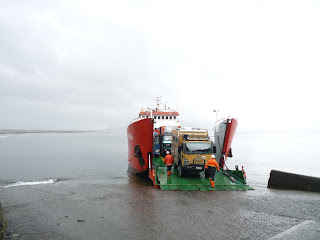
We didn't stop again until we reached Chaiten. This town was engulfed in ash in the 2008 volcanic eruption and still looks desolate. At the ferry office we wait while it pours with rain. John gets bored and heads to the info centre where he discovers that the ferry sitting at the port goes in 1 hour to Puerto Montt and costs the same as the shorter one to Quellon tomorrow. Fed up with the rain we impulsively decide to go tonight and sleep in GR2. It was really only a barge with 2 trucks and trailers and us. It rocked and rolled rather like driving through potholes. John popped a pill and slept. I was finally lulled to sleep after listening to him snoring and the cows mooing. Yes that truck was full of cows. Fortunately it was only a 12hr trip.

Saturday, March 12, 2011

PATAGONIAN PARCQUES

After Antartica it was great to get back into GR2 and return to our travels. We had a string of Nat Pks to visit. The first being Parque Nacional Tierra del Fuego about 30kms west of Ushuaia. It was a lovely spot to camp and hike in through the lenga forests. Then we retraced our steps north until we could turn off the main road, and follow some back roads. We left Tierra del Fuego via the cute little windswept town of Porvenier by ferry to Punta Arenas - the biggest Chilean city in the area. Then north to our next park, the wotld famous Park National Torres del Paine, stopping on the way at Cueva del Milodon to look at a huge cave where remains of a really old 4m high sloth was found. It was raining as we arrived at the park, but we started our hike to Lago Gray anyway. It cleared and we had great views of a huge irridescent blue iceberg floating in the lake, with the glacier in the distance. With good weather we enjoyed lots of hikes and fabulous scenery. Even the famous "torres" cleared for us to see. We finally pulled ourselves away after taking way too many photos and crossed the border back into Argentina and heading north.
After overnighting at the very touristy town of El Calafate we headed out to Parque Nacional Los Glacieres to see the Perito Moreno Glacier. We camped in the viewpoint carpark so in the morning we had the whole place to ourselves. The glacier was best enjoyed in before the busloads of tourists arrived. The glacier was calving (breaking) right in front of us. A truly amazing sight and sound show.
To visit the north section of the park we had to backtrack, bypass a few lakes and then head west to El Chaitan. The main star here is Mt Fitzroy (famous for always being shrouded in mist) - we had 2 perfect days with hardly a cloud in sight, it's towering rocky peaks visible from every direction.
Our next Nacional Parque is the little known Perito Moreno where there are very few tourists and gorgeous aqua lakes surrounded by a huge circle of mountains. There were lots of hikes and an abundance od wildlife. It was a perfect destination for GR2 with dirt roads & great camp spots.
Our last destination in Argentina is Cueva de los Manos - an ancient site of hand painting, incredibly similar to Aboriginal sites in Australia.
This section of our trip has included 100's of kms of dirt road, a chance meeting with GR2's big brother Bodo (owned by Leslie & Bruce), 3 more border crossings, a great meal of BBQ Patagonian lamb, and practically NO mobile phone range (as in outback Australia.)
We are now crossing back into Chile via Paso Roballos to start our drive on the Carreterra Austral.
Adios Amigos.

PATAGONIAN PARQUES

Parque Nacional Tierra del Fuego
Leaving Ushuaia
We won't use that one!!
One of many "dead sheds".......a bit more elaborate than our white crosses
Town of Porvenier
Punta Arenas - had a huge fishing industry at one time
The old & the new....Punta Arenas
Church in Punta Arenas
Punta Arenas was a very weathy city
Estancia we stopped at for lunch
Milodon Cave
The Sloth & I
Lago Gray & an amazing iceberg (glacier in the distance)
Parque Nacional Torres del Paine
Guanchos
More Torres -
Lots of dirt roads in Torres del Paine
Foxes in park
WOW - Moreno Glacier
Pretty amazing
Mt Fitzroy
Flamingos at Perito Moreno Nacional Parque
GR2 meets big brother - Bodo

Lots of hikes - need good boots, goretex pants, stick & painkillers for John & chcolate to keep Lynda motivated

Cueva de los Manos